Monday, August 13, 2012

Getting the picture

Have a look at the picture below. It shows a graph based on data calculated by the Pan-Arctic Ice Ocean Modeling and Assimilation System (PIOMAS) developed at the Applied Physics Laboratory/Polar Science Center at the University of Washington.
image from arctische pinguin - click to enlarge
The PIOMAS data for the annual minimum values are the black dots. The trend (in red) is added by Wipneus and points at 2015 as the year when ice volume will reach zero. Note that the red line points at the start of the year 2015. The minimum in September 2014 will be already be close to zero, with perhaps a few hundred cubic km remaining just north of Greenland and Canada.
image from arctische pinguin - click to enlarge
Above image, again based on PIOMAS data, shows trends added by Wipneus for each month of the year. The black line shows that the average for the month September looks set to reach zero a few months into the year 2015, while the average for October (purple line) will reach zero before the start of the year 2016. Similarly, the average for August (red line) looks set to reach zero before the start of the year 2016.

In conclusion, it looks like there will be no sea ice from August 2015 through to October 2015, while a further three months look set to reach zero in 2017, 2018 and 2019 (respectively July, November and June). Before the start of the year 2020, in other words, there will be zero sea ice for the six months from June through to November.

Actually, events may unfold even more rapidly. As the ice gets thinner, it becomes more prone to break up if there are storms. At the same time, the frequency and intensity of storms looks set to increase as temperatures rise and as there will be more open water in the Arctic Ocean. 


Above photo features Peter Wadhams, professor of Ocean Physics, and Head of the Polar Ocean Physics Group in the Department of Applied Mathematics and Theoretical Physics, University of Cambridge. Professor Wadhams has been measuring the sea ice in the Arctic for the 40 years, getting underneath the ice with the assistance of submarines, collecting ice thickness data and monitoring the thinning of the ice. This enabled 1970s data and 1980s data to be compared, which showed that the ice had thinned by about 15%. Satellite measurements only started in 1979.

Thinning of the ice is only one of the problems. "The next stage will be a collapse," Professor Wadhams warns, "where the winter growth is more than offset by the summer melt. If we look at the volume of ice that is present in the summer, the trend is so rapidly downwards that this collapse might happen within three or four years."

Apart from melting, strong winds can also influence sea ice extent, as happened in 2007 when much ice was driven across the Arctic Ocean by southerly winds. The fact that this occurred can only lead us to conclude that this could happen again. Natural variability offers no reason to rule out such a collapse, since natural variability works both ways, it could bring about such a collapse either earlier or later than models indicate.

In fact, the thinner the sea ice gets, the more likely an early collapse is to occur. It is accepted science that global warming will increase the intensity of extreme weather events, so more heavy winds and more intense storms can be expected to increasingly break up the remaining ice, both mechanically and by enhancing ocean heat transfer to the under-ice surface.

Recent events in the Arctic underline this warning. A huge cyclone battered the sea ice early August 2012. The image below, from The Cryosphere Today, shows a retreat in sea ice area to 3.09958 million km2 on the 222nd day of 2012, down from 3.91533 million km2 on the 212th day of 2012, i.e. 815,750 km2 less in ten days. Or, more than one-fifth less in just ten days.
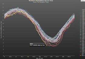
Image from  The Cryosphere Today - click to enlarge

Saturday, August 11, 2012

Storm exacerbates Arctic predicament

Image created by Sam Carana from sea ice maps generated by Polar View at the University of Bremen 
"What a difference a day makes", Sam Carana said when posting above image well before the Arctic was even bearing the full brunt of the storm. The NASA image below was captured on August 6, 2012, and shows that the center of the storm at that date was located in the middle of the Arctic Ocean.

Image by By NASA Goddard Photo and Video
John Nissen, Chair of the Arctic Methane Emergency Group (AMEG), comments:

"The storm is huge, and breaking up and destroying the sea ice that has become thin, as we feared would happen as the thickness has been declining steadily from year to year. Thus, as the end game for the ice, we are seeing more positive feedback and no sign of any negative feedback to rescue the situation.

There are at least three positive feedbacks working together to reinforce one another - and now a fourth on salinity:
  1. The albedo flip effect as sea ice is replaced by open water absorbing more sunlight, warming and melting more sea ice.
  2. As the sea ice gets very thin, it is liable to break up easily and get blown into open water where it will melt more easily.
  3. The open warmer water is allowing increased strength of storms, which break up the ice to make for more open water.
  4. The storms are churning up the sea to a depth of 500 metres, producing salinity at the surface that will mean slower ice formation in winter and more open water next year.
These feedbacks are dangerous for methane. AMEG has been warning that, as the sea ice retreats, storms will warm the sea bed, leading to further release of methane. In ESAS, we only need mixing to a depth of 50 metres - so a storm capable of mixing to 500 metres will really stir things up.

These feedbacks are also dangerous for food security, already damaged through climate extremes induced by Arctic warming, hence our piece in the Huffington Post.

The only way to head off catastrophe is to cool the Arctic, which must involve geoengineering as quickly as possible. We must try to remain positive and determined about this, despite the gloomy news."


Above image shows a retreat in sea ice area to 3.15521 million km2 on the 221st day of 2012, down from 3.91533 million km2 on the 212th day of 2012, from The Cryosphere Today.

The image below, from Polar View at the University of Bremen, shows sea ice concentration at August 10, 2012, with huge chunks of ice visibly detached from the main ice.

(Click here for full-size image)